High-resolution radar images from space shuttle mission will help Cornell unlock secrets of Andes geology
By Bill Steele
The history of the Andes mountain range is an epic and mysterious tale that a team of geologists at Cornell University has been tracing for two decades. Now the team's work is about to get a major boost from space-borne technology.
The Shuttle Radar Topography Mission (SRTM) of the space shuttle Endeavour, scheduled to fly this week, will map much of the surface of the Earth with a new high-resolution radar. Cornell researchers will help analyze the data obtained from the Andes region, funded by a $150,000, two-year grant from NASA.
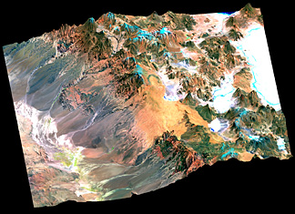
"There are many puzzles that remain about the Andes," says Bryan Isacks, the William and Katherine Snee Professor of Geological Sciences at Cornell and one of six Cornell faculty members working on the Cornell Andes Project in collaboration with several Latin American scientists. "There are parts of the Andes that have never been topographically mapped because of cloud cover, especially parts of the eastern side of the range. No satellite ever sees these areas from space. They are very remote and have never been surveyed on the ground. There is not even aerial photography."
Isacks is chair of the Department of Geological Sciences and director of the Institute for the Study of the Continents at Cornell.
Much of the Cornell work will focus on the Altiplano, a huge plateau surrounded by higher peaks and spreading through northern Argentina, western Bolivia and southern Peru. It is about 300 kilometers (188 miles) wide, 1,000 kilometers (625 miles) long and some 3,800 meters (two miles) in elevation and is home to Lake Titicaca, the highest navigable lake in the world.
"How this thing got raised up that way is still a fairly big mystery," Isacks says. "Being able to look at the topographic detail along the sides of it may go a long way."
Geologists do know, in a general way, how the Andes got there. Most of the floor of the southeastern Pacific Ocean rests on a single huge slab of the Earth's lithosphere (the outer skin comprising the crust and the uppermost mantle) called the Nazca plate, floating, like other such plates, on semimolten magma. Some 200 million years ago the eastern edge of the Nazca plate began shoving its way under the western edge of the South American plate, which makes up the continent itself and part of the South Atlantic Ocean floor. Like all geological processes, this "subduction" is a patient one, moving at about 8 to 10 centimeters (3 to 4 inches) a year.
The land above was lifted and squeezed. For much of the time, the effects were confined to what are now the coastal regions of Chile and Peru. Then, during the last 20 million years, the effects occurred over a much wider zone. Like a tablecloth shoved by a heavy platter, the crust folded and began thrusting up mountains so sharply that there is a drop of about 12,000 meters, or 40,000 feet from the western edge of the Andes to the Peru-Chile trench in the Pacific Ocean over a horizontal distance of only 125 kilometers (200 miles). A chain of volcanoes erupted along the mountain range. The subduction continues today, and the area remains volcanically active and subject to devastating earthquakes. Understanding more about the geology of the region might help to predict and prepare for quakes, Isacks says.
Further, he says, "Knowing the topography in the upper headwaters of the Amazon is very important for understanding the hydrology of the Amazon. It fits into global change research."
For the SRTM mission, the Endeavour will use two radar antennas, one on board the shuttle and the other at the end of a special 60-meter (200-foot) mast. By combining signals from the two widely separated antennas, using a technique called radar interferometry, scientists will be able to construct three-dimensional images of the land below, somewhat the way our eyes see depth by combining two images from slightly different angles. The radar also will return information about the characteristics of the surface.
The shuttle's orbit around the Earth will be tilted 57 degrees with respect to the equator, enabling it to map all of the Earth's surface from latitudes 60 degrees north to 56 degrees south, or about 80 percent of the planet. The radar will resolve details as small as 30 meters across. Except for limited areas, existing maps of many remote mountainous regions such as the Andes, whether from radar or conventional ground-based mapping, have a resolution of only about 1 kilometer.
NASA plans to produce detailed topographic maps of the Earth's entire surface but also will supply the raw data and provide research grants to about 40 groups of scientists worldwide for more detailed analysis.
Cornell expects to start receiving data from the SRTM mission this summer and will spend a year or two analyzing it, Isacks says.
As for the Andes data that Cornell will receive, "It will fill in huge gaping areas that we don't know about," Isacks says. "You can analyze the elevation data as a mathematical surface. You can identify active faults, and you can analyze the river systems to estimate how fast the mountains are uplifting and eroding," he says enthusiastically.
"We're not just looking at a color picture of topography. That's what you get at the end, but there's a lot of analysis before that," he explains. "It will answer basic questions about how the world works."
Media Contact
Get Cornell news delivered right to your inbox.
Subscribe