4-H leaders learn geospatial technology
By Krishna Ramanujan
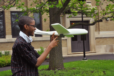
Small teams of educators designed strategies to fit foam gliders with keychain cameras to replicate video fly-bys as part of the 2014 Geospatial In-Service workshop, attended by 11 4-H educators and leaders on campus June 10-12.
The workshop, hosted by the Institute for Resource Information Sciences (IRIS) extension, taught 4-H educators, volunteer leaders and youth leaders about global positioning systems (GPS), geographic information systems and remote sensing tools, which participants plan to introduce to their New York counties through 4-H, a program of Cornell Cooperative Extension (CCE).
“One of the [workshop] goals is to build capacity in our 4-H system using the tools of GPS science and technology for youth and community betterment,” said Susan Hoskins, senior extension associate at IRIS who leads the 4-H Geospatial Sciences program. “In our everyday lives, GPS science and technology is embedded in everything we do” – within applications in cell phones and computers, for example, so it is important to expose young people to these technologies, she added.
In one lesson, participants learned how to map projects in their own communities. They used an online mapping interface on computer tablets to collect data on challenges to accessibility on a pathway between two buildings on Cornell’s campus. “We exposed them to the Web interface and had them collect data, identify issues and make notations,” said Stephen Smith, senior extension associate at IRIS. In the past, educators and 4-H members inventoried fire hydrants in two counties and gave the information to fire and planning departments.
“To take this information and use it in youth programs and apply it to STEM programs in place now is tremendous,” said Susan Hagar, a 4-H volunteer leader in Clinton County and a workshop participant. She plans to use the skills she learned to teach her 4-H group to develop trail systems, demarcate sugar bush maple stands, design a solar panel system and train volunteer leaders.
Participants also learned about Adopt-a-Pixel, a NASA and U.S. Geological Survey citizen science project with 4-H, the National Parks Service and the New Mexico Museum of Natural History and Science. Citizens locate ground coordinates and take photos in four directions and up and down, and the photos are entered into a database as ground references for satellite imagery.
Workshop staff included Charles W. Malone, extension educator, CCE of Genesee County; Jim Hooper, extension resource educator, CCE of Ontario County; Lori Radcliff-Woods, administrative assistant at IRIS; and Ciara Rodriguez, a College of Agriculture and Life Sciences summer intern.
Media Contact
Get Cornell news delivered right to your inbox.
Subscribe